

This is how I picture the first metro map in Ottawa. Imagine how pleasant it would be to go see a concert at the Scotia Bank Place from your home in Orleans without having to drive in traffic, or how enjoyable it would be to leave your home in Kanata in the winter for a night out in the market without having to find parking.
A proper metro system should connect all the universities and colleges to downtown as well as important locations such as the Scotia Bank Place, the airport, the train station and the Casino. Having an underground metro system in Ottawa would greatly increase the mobility of people and connectivity between places. It would most likely boost the economy as well, since it would be easier, faster and cheaper for people to move around the city without needing a car.
If I was to design a metro map for Ottawa, I would start with 7 lines. Here's what I envision :
The Red Line

There would be a main line going from Kanata to Orleans. This would greatly alleviate the traffic on the 417 and allow the many people who live in the suburbs and work downtown to commute a lot faster and easier. (No more cursing at the bus driver who didn't stop for you). This line would connect the Scotia Bank Place, the Kanata Centrum, the Bayshore Mall, Tunney's Pasture, the University of Ottawa, La Cite Collegiale, Place d'Orleans Mall and the Shenkman Art Centre. The Red Line would also be connected to five other lines running North-South.
The Orange Line

The Orange Line would run parallel to the red line but a little more to the North. It would connect the War Museum, Spark Street Mall (a nicer one), the Parliament, the Rideau Center and Beechwood. The Orange Line would also be connected to three other lines running North-South.
The Orange Line
The Orange Line would run parallel to the red line but a little more to the North. It would connect the War Museum, Spark Street Mall (a nicer one), the Parliament, the Rideau Center and Beechwood. The Orange Line would also be connected to three other lines running North-South.
The Purple Line

The purple line would go from Bells Corner, pass through IKEA, Algonquin College, Carleton University, Spark Street all the way to the Casino in Gatineau : very practical for people living in Gatineau and working in Ottawa.
The Yellow Line
 The Yellow Line would be the main North-South line, connecting the airport to downtown and a portion of Gatineau as well. This would considerably alleviate traffic specially considering the fact that there's only one main road from downtown to the new CE Centre. This line would run along Bank Street and would would most likely boost the businesses in the area and help with traffic along Lansdowne.
The Teal Line

The Teal line would connect the Byward Market to the metro system as well as St-Paul University. It could eventually expand further south to include areas such as Greenboro and Leitrim.
The Blue Line
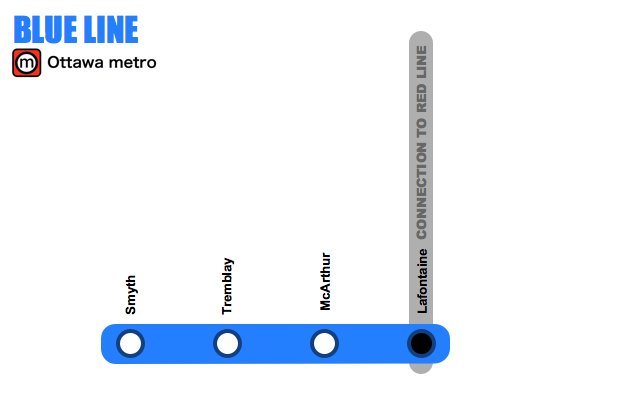
The main purpose of the Blue Line would be to connect the train station to the subway system. This line could also be expanded depending on the need for it.
The Green Line

The Green line would mostly run along St-Laurent, giving better access to a lot of the retailers along the street, including the St-Laurent Mall and also connect tourist attractions such as the RCMP musical ride and the Ottawa Science Museum.
So there you have it! Metro's have been around since 1863 (in London). There are now over 183 metros around the world. The largest one (423 km) is in Shanghai (China) and the smallest one (1.8 km) is in Haifa (Israel). However the one with the most station is in New York (468 stations, 368 km)
The current proposed metro system for Ottawa (76 stations, 63 km) would be comparable to the one in Montreal built in 1966 (73 stations, 69 km). Given that we're in the 21st century however, the system would have to be a lot more technologically advanced.
Reference : World Metro Database

 A modern city needs a proper transportation system and Ottawa does not have it yet. Although the
  The main "issue" with the streets downtown Ottawa is that most are very narrow. They were not built for buses, on top of cars, on top of bicycles, on top of pedestrians. The population is increasing but the available space has not changed. It just gets more crowded. And with the green belt, we can't really expand either.

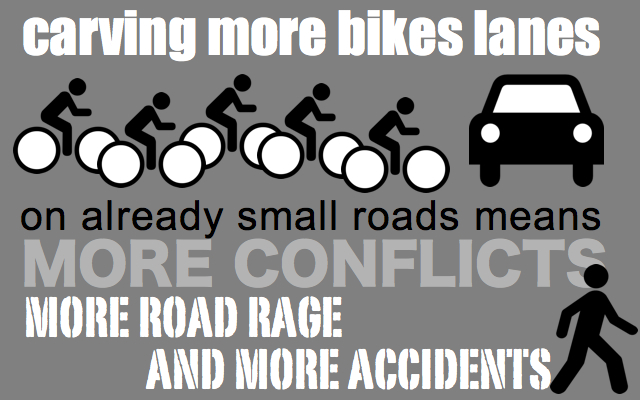 Adding more bike lanes may sound like a good idea at first, but since they just end up taking space where there already isn't enough, this ends up making things worst. The number of limited parking spaces and stopping zones is reduced and we found ourselves in situations where delivery trucks, for example, have to block the bike lanes and/or traffic. It's just a mess.

